Looking to hike Havasu Falls but not sure what the deal is or where to start? Read on for some tips to help you get a permit, and for during your stay in the canyon!
Read More
Looking to hike Havasu Falls but not sure what the deal is or where to start? Read on for some tips to help you get a permit, and for during your stay in the canyon!
Read MoreThe San Juans may be the most beautiful mountain range in Colorado. They span Southwestern Colorado and Northwestern New Mexico, and the main towns were once mining hubs. One of the most popular hikes in the area is to Ice Lake and Island Lake, in the Ice Lake Basin.
Read MoreJust over an hour west of Denver, Mt. Bierstadt is another 14’er that is jam packed because of its proximity to the front range and ease.
Read MoreOur hike up Grey’s and Torreys was completely in the dark until about 30 minutes from the summit, and it was a quite chilly morning! We had prepared for some cold but we would have welcomed another layer and warmer gloves. There was a cloud inversion, combined with a light sunrise, which made for a beautiful view. We didn’t last up top long though because of the howling wind- and trying to shelter by a wall of rocks did us no good.
Read MoreLocated just under 30 minutes from Breckenridge, Quandary Peak is one of Colorado’s most climbed 14’er because of its reputation of being on the easier side. Parking for this hike used to congest the road leading in and it led to unsafe road conditions, so to reduce that there is a parking lot reservation system or you can take a shuttle from the Breckenridge Gondola Lot. Read more here on how to access Quandary Peak.
Read MoreEven though it’s still nighttime, it’s warm out in Buena Vista. We make the twenty minute drive to the trailhead, and at 5:15am there is still a number of spots left in the parking lot. I’d had this pre-conceived notion that 14’ers were going to ruin me, but I was pleasantly surprised (by Mt. Yale, at least). It’s the 20th highest 14’er at 14,200’ elevation. Growing up hiking in the White Mountains of New Hampshire, this 14’er was no harder than some of the trails out there.
Read MoreLooking for a moderate hike with wildflowers and under 2 hours from Denver? The secret is out, thanks to social media. Acorn Creek Loop in Silverthorne, Colorado has become a popular wildflower hike after going viral on TikTok. Located off a dirt road in the Ptarmigan Peak Wilderness, this loop is just under 5 miles and is a moderate difficulty. It’s no 14’er, but there is a constant incline no matter which direction you do the loop in.
Read MoreFollowing the Colorado River, Route 128 will eventually have a right hand turn on to BLM 98. Its down this road that you’ll reach Professor Creek and Mary Jane Canyon, a 9 mile round trip, BLM 98 is stuh-nning, A red dirt road going off into the horizon, flanked by greenery, and backdropped by mountains. It’s a good option for an easy hike in Moab, as it is pretty flat. The difficulty, comes from the distance and heat.
Read MoreEven with just half a day, you can have a great time in America’s National Parks. Read on to see how to spend a morning at Arches National Park in Utah with stops at Delicate Arch, the Windows, and Devil’s Garden. You’ll see why this park is called Arches, and you’ll be in awe of the reddish brown clay forming monstrous structures around you.
Read MoreBanff National Park is one of the most popular National Parks in North America. It has many shining jewels, one of them being Lake Louise. There are multiple trails that start from Lake Louise, one of them being the Lake Agnes Trail to the Lake Agnes Teahouse. Read on for more information about this beautiful and easy trail in Banff National Park.
Read MoreLocated in Summit County past Copper Mountain (coming from the West), Mayflower Gulch is an easy hike with a big reward. It’s just a little over 3 miles round trip, up a low-incline jeep trail that eventually opens up into the jaw-dropping gulch.
Read MoreMaroon Bells are the most photographed peaks in Colorado, and some of the top in the country. And it’s for good reason- the two bell shaped peaks rise tall above Maroon Lake giving off a dramatic and jaw-dropping scene (they’re 14’ers).
Read MoreRed Rocks Amphitheatre is 30 minutes outside of Denver and has a capacity of 9,500. It is a notable venue as it is built into the massive red rocks caused by iron oxide and pink feldspar. The park is 738 acres and adjacent to the amphitheatre there is the opportunity for a brief walk/hike.
Read MoreOk- so it wasn’t quite 10 miles, but 9.34 miles is close enough! This trail is located in the Wildernest area of Silverthorne and goes to the South Willow Creek Falls. This was my first trip to Colorado, and thus my first hike there! This trail took up a solid chunk of the day, we spent just under 5 hours out/back, and 3 hours 50 minutes were spent hiking.
Read MoreI knew that Mt. Tom was going to be a viewless summit- but I didn’t realize that Mt. Field and Mt. Willey would be too. When I did my research, I originally only looked up Mt. Tom and then a trail map on how the three peaks are connected. I’m definitely someone who hikes for views so it was a little disappointing to be greeted by three piles of rocks, but it is what it is!
Read MoreStuðlagil Canyon has soared in popularity for its towering basalt columns with blue water that is reminiscent of a Cool Blue Gatorade. Located in Eastern Iceland, this spectacle was unearthed when the dam Kárahnjúkavirkjun was created in 2009, lowering the river water to reveal the columns.
Read MoreMy first post about my backpacking gear reviewed 6 very crucial backpacking items. Since then, I’ve happily added to my setup to make life in the back country even better! Read on to see some of the items that I like to bring with me on overnight trips.
Read MoreThe Bonds Traverse is just over a 22 mile out and back hike in the Pemigewasett wilderness of the White Mountains. The trail is rated as difficult, likely due to it’s length. The actual terrain of the hike is a moderate incline for the majority of the trail with a few river crossings. Should you want to make it into an overnight backpacking trip, the Guyot Shelter is on a spur trail by West Bond.
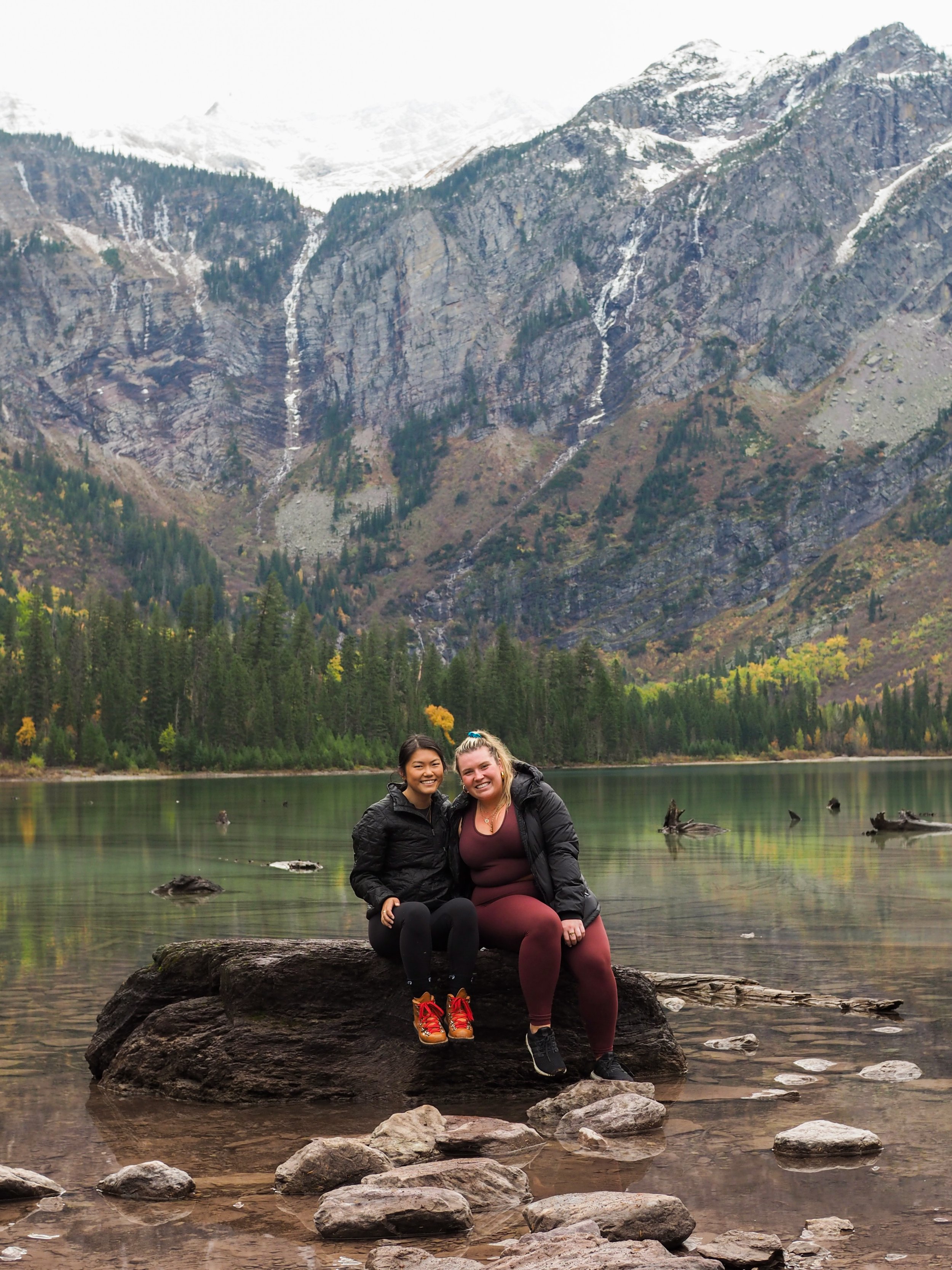
Read MoreOne of the most popular hikes in Glacier National Park, Avalanche Lake is around a 6 mile round-trip hike through the forest- and the hike begins on a trail that is aptly called Trail of the Cedars.
The hike to Avalanche lake is very manageable and I would rate it an easy-moderate.
Read MoreLocated in Carroll, New Hampshire, Mount Jackson is one of the shorter 4000’ers at 4,052’. My friend Kayleigh and I started this hike at midnight on October 8th, summited just before 2am, and then laid out our sleeping pads and sleeping bags until sunrise.
The hike up was easy-moderate, it wasn’t super steep but the majority of the path involved stepping around rocks and roots- it felt like more than some trails. The end of the trail was the hardest with some scrambling to do. My guess is this would have been a little easier to do in the daylight!
Read More